The history of the Grand Canyon can be told by analyzing its layers of rock and while these impressive layers can be easily viewed throughout the Canyon, some of the first layers are tough to spot unless you know where to look.
 Our story begins with the canyon’s oldest layer of rock; the Vishnu Formation is comprised of schist, gneiss and granite. Its evolution is fascinating in that what began as sedimentary rock, over time, got pushed down so deep into the earth; it sustained scorching temperatures, changing it into dark, metamorphic rock. It is found in the Inner Gorge of the Grand Canyon.Vishnu Formation
Grand Canyon Supergroup
Estimated to be between 1.2 billion and 800 million years old, the group of sedimentary and volcanic rock known as the Grand Canyon Supergroup formed, turning into miniature mountain ranges. The Supergroup consists of two main layers of rock that were separated by some 300 million years! The thin layer separating the two Supergroup layers is called the Nankoweap Formation.
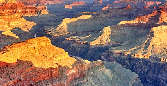
These layers of rock are visually interesting as their layering is tilted and lightly colored. Erosion eventually wiped out these Supergroup mountain ranges but you can still view the layers in some places.
Check it out! The ancient Supergroup layer can be still be seen from Desert View, the eastern most developed part of the Canyon near the South Rim.
Tapeats Sandstone Layer
Moving into the Supergroup’s place, the Tapeats Sandstone Layer settled on top of the Vishnu Formation, but there is a billion year gap in the layers between the metamorphic rock at the bottom and the first layer of sedimentary rock. Over that time, thick layer of sedimentary rock was laid down and eroded away leaving a huge void of information about those years. It confounds geologists and is known as the Great Unconformity.
Bright Angel Shale
A blue-gray layer of shale sites atom the Tapeats Sandstone known as Bright Angel Shale. The two layers differ dramatically in composition, largely due to the fact the water had become deeper and calmer in the area, allowing a finer grain of sediment to form at the bottom, eventually forming the shale.
Muav Limestone
Bits of shell can be found in the limestone that formed the Muave Limestone layer.
Temple Butte Formation
This rare looking freshwater limestone is a beautiful purple hue and is thought to be approximately 385 years old.
Redwall Limestone
This impressive layer forms some of the Canyon’s steepest cliffs. This limestone layer appears silver in color under the surface and has been stained red by iron oxide from the rocks above.
Supai Group
Aptly named for its grouping of rock consisting of shale, sandstone and siltsone, the Supai Group is believed to have formed about 300 million years ago along shorelines. Fossils of insects can be found in this layer.
Hermit Shale Layer
The Hermit Shale Layer is a rich red color just above the Supai Group, above the Redwall cliffs.
Coconino Sandstone Layer
Thanks to its slanted lines and unique appearance due to its influence from the dunes, this is the easiest layer of rock to identify in the Grand Canyon.
Toroweap Formation and Kaibab Limestone Layer
The top layers of the canyon (the youngest) are lightly colored. The Toroweap is a yellowish-gray color while the Kaibab Limestone is cream colored.
Check it out! Much of these layers have eroded away, but can still be seen east from Desert View to Cedar Mountain and northeast to the Vermillion and Echo cliffs.
The Storied Colorado Plateau
The Grand Canyon itself is actually a huge crack in the Colorado Plateau. This “crack” was formed by subduction, a process by which a continental plate bumps up against a heavier, oceanic plate. This collision forces the denser plate (oceanic) underneath it, raising the land. The friction caused by these gigantic rock formations caused the water to heat up, melting lighter minerals and creating lava.
Check in out! An excellent example of the shift in plates can be observed in the Four Corners area, as this exact event took place and was named the Laramid Orogeny. In this case, the Pacific Ocean plate was shoved underneath the North American plate, pushing the land up to 13,000 feet in some areas. That’s quite an elevation change!
You might think the process of subduction would lead to a dramatic collapse of mountaintops, but because the earth’s crust is so dense underneath the Grand Canyon, some rocks merely folded in a single layer instead of breaking apart. These are called, monoclines.
Check it out! You can see these impressive monoclines yourself by car from both rims! Drive from Lee’s Ferry to Jacob Lake on the North Rim and you will ascend the East Kaibab monocline. Driving east from Grandview Point, you can descend the Grandview monocline.
A River Runs Through It
To this day, scientists still can’t agree on how the Colorado River ended up where it is today. Early explorer John Wesley Powell, who completed some of the mapping of the Grand Canyon in the mid-late 1800’s, thought the river cut through the rock as the land rose when the plates shifted. Geologists agree the eastern side of the canyon is old enough to support Powell’s theory, but the western canyon is much younger.
The Canyon Walls: A Continuing Education
Close to 40 identified rock layers make up the walls of the Grand Canyon and because most of them are visible throughout the park, thousands of interested visitors flock to the Canyon to see it for themselves. Even after all these years, geologists are still learning about how the changing environment impacts the earth.
Check it out! If you truly think geology rocks, consider participating in the Geologist in Park program, sponsored by the National Parks Service.